Showing posts with label Walk. Show all posts

A Classic Italian Hike for Families, Couples, Trekkers.

A Guide to One of Italy's Best Easy Hike Destinations. 

  A Great Thing To Do with Children & Teens. A Stunning Picnic Spot. 

An Excellent Attraction near Reggio Emilia (1 hr.)  Parma & Modena (1¼)  Liguria & Lunigiana (1½).  


The Pietra of Bismantova provides spectacular views & an easy hike.
The Pietra of Bismantova provides spectacular views, but the easiest trail only takes 20 minutes and it's family friendly.

Treat yourself and your family to one of the great natural attractions of Italy. This spectacular geologic feature will remain in your memory and your photos for much longer than a postcard or the next spaghetti bolognese.

The oddly named Stone of Bismantova will surprise you with a majesty that speaks to the nature in your soul. It stands above its surroundings as a sentinel, as a symbol, as an aspiration. Primitive man climbed it, ascetics were drawn to it, local culture incorporated it, Italian youth are introduced to nature by it, and you can easily experience it for yourself.

PIETRA BISMANTOVA
The Pietra of Bismantova dominates the surrounding area
Dante alluded to the mountain as Purgatory and the top as the
Garden of Eden. So says every hiker.  CC by Paolo da Reggio
You will see its unmistakable form rising isolated from the landscape from miles away. The Pietra dominates the surrounding area - overlooking it from a height of about 300 meters (1,000 feet) and many sections of the cliffs are 100 meters high!  It is roughly one kilometer long by 240 meters wide.

The unique shape is due to the type of limestone which forms the mountain. Simply put, it resisted erosion better than the surrounding area over the last 20 million years. The rock was formed from sediments in an ancient sea and there are fossils in some areas as well as visible patterns from undersea currents during deposition. The rocks are partly sandstone but mostly calcarenite which is the limestone equivalent of sandstone. This is formed from deposits of carbonate bits that were pressed together into rock from diverse sources such as sand-sized limestone fragments, shells, corals, shark teeth, oodles of ooids (precipitated calcite), etc.

HISTORY
Of course, it was inhabited by prehistoric people - there's a Copper & Bronze Age archeological site and a necropolis near the Pietra's base at Campo Pianelli.  Subsequently, there's evidence that site was used by Etruscans and Celtic-Ligurian tribes. Naturally, the Pietra was fortified, probably until the 15th C. - first by the Romans, then the Byzantines, the Longobards, then Charlemagne, and finally by Matilda of Canossa. There little evidence left of the fortifications today.


The views from the cliffs of Italy's Bismantova are endless.
The views from the top of Bismantova are endless.

For the surrounding towns. the history concerning the Pietra is religious - involving devotion and pilgrimage to the Madonna della Pietra. The Eremo di Bismantova (Hermitage) at the base was established by Benedictines in the 1400's and rebuilt in the 1600's. There are frescos inside from the 1400's, including a depiction of the Madonna. Today, the Eremo is part of the Marian order.

Dante Alighieri visited Pietra di Bismantova in 1307. The Mountain of Purgatorio, mentioned in Canto IV of Purgatorio in the "Divine Comedy", was seemingly inspired by Pietra's unique formation. As if to inspire hikers, the Garden of Eden was located on top.

In the last few centuries, the summit was only used for grazing which explains the nice pastures and the easy views we enjoy. Slowly, the trees are regaining control, but it's slow going due to the altitude and the nearby Alps.  Today the Pietra di Bismantova is protected as part of the National Park of the Apennines. Parco Nazional Apennino Tosco-Emiliano (EN). 

HOW TO HIKE THE PIETRA
The starting point of Pietra di Bismantova activity is Piazzale Dante at the end of Via Bismantova in Castelnovo ne' Monte (RE). See GETTING THERE below. There is free parking as well as the Eremo (Hermitage) nearby, the Rifugio di Bismantova bar-restaurant and the Albergo Forestiera.

★Before you go: Download this Pietra Bismantova Hiking Map to a portable device. Why? It is clearer than the posted map on site, and there are no trail signs or maps on the actual summit. There are also no services on the summit, so at least take sufficient water with you.

The easy hiking trail on Italy's Pietra di Bismantova in October.

This is an active recreational attraction, so there are several choices.  The most popular climb is a section of Trail 697 which angles directly to the top. It's the shortest, it's not particularly hard, and takes about 20 minutes. The second most popular is the 6 km. 'L'anello della Pietra' (Ring around the Stone) using Trail 697 which combines a very scenic nature walk around the Pietra with a visit to the summit. It takes about 2 hours.  Both routes leave from Piazzale Dante and below we describe both ascents, as well as the most popular part of the summit and the descent they share. We think school-aged children who like hiking will have no problems with these two hikes.


Other recreational options include:
-Several other trails, such as Trail 699, which are steeper, rockier, and reach the top from different directions.
-Two via ferrata routes are in place for an alpine experience (i.e. straight up).
-There are also many sport rock climbing opportunities on the cliffs with numerous bolts apparent.
-Climbing (bouldering) is also an attraction on the gigantic fallen rocks around the base of the Pietra.

A Beautiful Seaside Walk from Rapallo to Santa Margherita.


The Red Carpet Walk from Rapallo to Santa Margherita & Portofino.  

A Great Thing to Do - Explore Between Rapallo & Santa Margherita.


 Enjoy the Attraction of Villas, Free Beaches, Grand Hotels and a Baroque Church.


Aerial of San Michele di Pagana with Pomaro, Trelo (Travello), & Prelo Bays.  Beyond is Santa Margherita & Parco Naturale di Portofino.
A beautiful coastal walk through San Michele di Pagana with its three bays: R. to L. Pomaro, Trelo (Travello), & Prelo.
Santa Margherita is beyond with Parco Naturale di Portofino as a backdrop. Photo: Archivio Storico della Regione Liguria.

It's now a pleasure to walk from Rapallo to Santa Margherita Ligure (SML) along the coast between these pretty Ligurian towns - thanks to recent sidewalk improvements. The walk was inaugurated with the World's Longest Red Carpet - 8 km. from Rapallo to SML to Portofino. The carpet is gone now, of course, but the beauty remains.  This article covers the first half of the coastal walk, the second half is our popular article  Walk or Hike from Santa Margherita to Portofino  which also describes an easy hill hike with beautiful overviews.

The route is full of sea scenes and garden glimpses and villa views so you can really get a feel for this beautiful area.  We recently explored it and we discovered four free beaches (spiaggia libera); a WWI Memorial forest; a Baroque church; and all the while we were surrounded by grand mansions and hotels, gardens and the sea. 

Villa Lagomaggiore in Rapallo on Capo Pomaro (Punta Logon).
Our walk passes inland behind Villa Lagomaggiore on Capo Pomaro.
The walk is great for both kids and adults and the hills are gentle. This route is about 3 km. (2 miles) and it can be done in 45 minutes, but don't you dare hurry. Allow 90 minutes to be leisurely, and it's easy to spend a couple of hours if you are experienced in smelling the roses. It is quite doable with a stroller except harder in the Punta Pagana section where there are two short sandy beaches and two staircases. There are some services at the first beach at Pomaro about 1/3 of the way, but bring some water anyway.

You can create a personalized round trip using the bus that runs along the seaside road or by boarding the ferry at SML or Rapallo or Portofino. See the links at MORE INFO below.

OUR DIRECTIONS:   WALK THIS WAY.
We begin on the western side of Rapallo - across the canal-like Boate river - where we follow Corso Cristoforo Colombo as it heads toward the sea from the intersection with Via Aurelia Occidental. This is near the Hotel Stella and there are blue traffic signs pointing the way to SML and Portofino. As you start, there are good views of Rapallo's extensive harbor which is a major port for private boats of every description and tax bracket. Soon the road  curves away uphill past the Hotel Excelsior Palace. Corso Colombo changes names, but it's always the largest choice. It's known later as Via San Michele di Pagana then as Via Bridiga Morello a/k/a Strada Provinciale 227 (SP227).

We walk all the way from Rapallo to SML on the sidewalk along this road and we just take one detour at Travello. We describe several sights you will miss without that detour around Punta Pagana (a small peninsula), and we add details on some places you'll see along the way.

Walk or Hike from Santa Margherita to Portofino

A Travel Guide for Getting to Portofino -Walk, Boat or Bus.

Hike the Portofino Hills or Walk to Portofino by the Seashore.  

_________________________________________________

You will love the walk to Portofino from Santa Margherita ! This wonderful Italian Riviera icon has been attracting the rich, the famous, and the ordinary since before Ligurian Pesto was invented.* Just everyone wants to see what the fuss is about. It's a serious question. Why would Giorgio Armani and Dolce & Gabbana have villas in a little fishing village? Since it's at the end of a peninsula and there's a crush of your fellow humans with the same idea, you need our help. We visited twice recently, with paper and pen and camera, to walk from wonderful Santa Margherita Ligure (SML) to Portofino. We also provide all the information you need to visit Portofino.
Portofino Harbor, Liguria
Portofino Harbor, Liguria                                          K. Hurley

Getting to Portofino Your choices are walking or using a bus, ferry boat, water taxi, or taxi. Driving your car rental to Portofino is a losing proposition. If you are allowed on the road at all, there are perpetual traffic jams and very little parking. The closest you can get by train is Santa Margherita. If you are able, we highly recommend you walk at least one way for a complete experience. This article describes the level seaside walk and a hilly but direct hike from Santa Margherita Ligure to Portofino. See More Info below for the other transport modes and resources for longer and different hikes.

The Safe Red Carpet Walk  Until recently, the walk from Rapallo to Santa Margherita Ligure to Portofino was a challenge, and not one to be taken lightly. It was a narrow road curving scenically along a beautiful coast, past promontories, villas, sandy beaches, and craggy outcrops. However, there was two way traffic, including buses, and no sidewalk for much of the way. There are a lot of out-of-date travel websites that still describe it that way. Fortunately, things have changed.

It's now a pleasure to walk to Portofino along the coast between these pretty Ligurian towns - thanks to sidewalk improvements. The walk was inaugurated with the World's Longest Red Carpet - 8 km. from Rapallo to SML to Portofino. The carpet is gone now, of course, but the beauty remains.  This article covers the coastal walk from Santa Margherita to Portofino. The coastal walk from Rapallo to Santa Margherita is our new article  A Beautiful Seaside Walk Along the Portofino Coast .


Seaside Walk, Santa Margherita to Portofino
Walkers and joggers now have the best views from a sidewalk or boardwalk running along the seaside of the road - suspended next to the road in the narrowest sections. Strolling couples, hikers with back packs, families with baby carriages share the walk, smiling and greeting each other as proper vacationers do. The view is to the south, the hills of the Italian Riviera meeting the bays and inlets of the Bay of Tigullio. The water is a constantly changing mosaic of blues that range from indigo to light aqua, with sunbathers below here and there on sand if available, on pebbles and rocks if not. In the shallows just below, you might see sport divers with enormous flippers searching for sea food.

Walkway to Portofino
The walk is easy and takes about 75 minutes since it's only 5.4 km - just over 3 miles - from the center of SML. Our directions are short: walk west along the shore. There’s only one section of about 50 feet where there isn't room for a sidewalk, and you pay close attention, then you’re back to your casual stroll.  Just over half way is Paraggi, a perfect cove with services and a beach, where the song Love In Portofino was written. The sidewalk then crosses the road and continues as a paved path in a pretty forest with gentle ups and downs. The views of the ocean, the rocky shore, and a few villas are artfully framed by pines and oaks.

There are a couple of different descents once you approach Portofino, and they’re all good ways to reach the famous piazzetta. Take the first stairway down, and you’ll descend to the near side of the pretty port, with boats, restaurants, shops, and plenty of places to sit and admire the views. Follow the path all the way and you'll arrive at the Church of San Martino to enter the small town from the land side.
_________________________________________________________________________________
Where to Stay to See Portofino?  We Love Santa Margherita.
 
 Liguria Hotel Guide & City Selector
Minimize the crowds and enjoy Portofino, Cinque Terre, & Liguria. We help you choose your location with the Pluses & Minuses for each town or city:
Link: Part 1: Cinque Terre South - Gulf of the Poets
Link: Part 2: Cinque Terre North to Portofino
Link: Part 3: Towns on the Portofino Peninsula
____________________________________________

_________________________________________________________________________________

The Overview Hike
View from Madonna della Neve toward Portofino
There's a pleasant and direct hike from Santa Margherita Ligure to Portofino that provides excellent views of the south side of the Portofino Promontory. Overviews of SML will give way to glimpses of old villas and old farms. You'll pass little chapels and have the coast laid out in front of you like a travel brochure. There are flowers and vines, forested sections and garden scenes.

The hike takes less than 2 hours to reach Portofino from its unpromising start behind an IP gas station near the west end of Santa Margherita's harbor. It is hilly, but it's not torture. It is suitable for energetic children, but it could be slippery on the way down if there has been recent rain. The place names along the hike are:  SML-Madonna della Neve-Nozarego-Cappella di Gave-Paraggi, and the Paraggi-Portofino sidewalk as above. The blazes are red 'plus' and then red 'three dot'.


Olive Trees with Harvest Nets on the Portofino Slopes
The hike starts with a steady hill climb on Salita Montebello in direction Nozarego and the views are a quick reward. The trails have periodic signs, so you'll have little trouble (note: you are not heading to Portofino Vetta as vetta = summit). When the first hill levels off, you are near the chapel of Madonna della Neve, and it's a nice place to rest and look. When you restart, you'll be on a road for about a 100 meters, then there's a left up a ramp toward a small group of old houses.

The hike continues past villas and gardens and olive groves, bordered often by stone walls. The views are inland here and seaward there, but always pleasantly distracting. When you reach Cappelletta di Gave, a tiny settlement, there's a marked trail junction, and our trail starts down. The descent is often walled, but after 15 minutes you arrive at Paraggi and there's lots to look at as you join the seaside walk described above.
Travel Tip___________________________________________________________________
Renting A Car in Italy.  Car rental prices are important, but don't rent based solely on low price and stick to well known companies. We have two articles to help you:        
                                          Link: Independent Car Rental Reviews for Italy 
                             Link:Car Rental Tips for Italy - Pick It Up Right 
We advise getting your car from one of the companies with the fewest problems reported (Avis, Europcar, Hertz, Autovia, Budget) either direct or via a reputable car rental broker such as AutoEurope. The advantages of using AutoEurope are the added services without paying more - 24/7 help line before, during, and after the rental; easy changes and cancellation; as well as available less expensive zero excess (deductible) insurance. Using these links do not raise your price.
AutoEurope(US)  Auto Europe(UK)    Avis(English)    Avis(IT)      Budget Rent A Car (English)
_________________________________________________________________________________

More Info
Read about the song that drew you here, whether you know it or not: Portofino - History of A Famous Place.

How to Bus to Portofino ATP Bus 82 leave Portofino about every 20 minutes from 6:15 AM to 11:15 PM (to 12:45 AM in summer). In Portofino the bus stop is where the SML road enters town. Nearby is a ticket vending machine, and the one-way fare was 3.00€ in March, 2019. In SML, catch the bus in the center of town or at stops along the route to Portofino. Buy tickets at a ticket machine, the tourist office or a news kiosk or at more expense on the bus. Remember to validate your ticket upon entering the rear of the bus. See ATP Bus 82 Info Sheet and ATP Bus Website Home (click Servizi per Utente / Percorsi e Orari / then the SML - Portofino map segment).

Ferry Boats to Portofino
Ferry boats operate along the coast from March through October, and it's a great way to see the famous coastline. We have an article with complete information, including ferries to Cinque Terre: Portofino Ferry Boat Schedules from Rapallo & SML

Local Artist Painting in Portofino Harbor
A Local Artist Painting in Portofino Harbor
Servizio Marittimo del Tigullio operates the ferry boats around this Gulf of Tigullio, serving Portofino, Rapallo, Santa Margherita Ligure, Sestri Levante, Chiavari, Lavagna, San Fruttuoso, Portovenere and Cinque Terre. All the times are in our article.

From Camogli. For ferry boats on the Liguria's Gulf of Paradise to the north read: Camogli to San Fruttuoso Ferry Boats with Recco & Portofino. There is info for boats serving Recco, Camogli, Punta Chiappa, San Fruttuoso, Portofino, You can create a ring tour by changing ferries at San Fruttuoso. For example boat SML-Portofino-San Fruttuoso, then  boat San Fruttuoso-Camogli, then train Camogli-SML.

Water Taxi to Portofino  You may want to consider this mode when travelling with more than 4 people, or if you are feeling flush. For example, the captain in SML said it cost 100E for a round trip to Portofino, 200E for both Portofino and San Fruttuoso including wait time with the trip including as many as 12 people.
SMI Water Taxi. On the dock near the ferry. 339-8414266.
Cesare Charter. On the pier in Portofino 340-7926139 or 349-3109959. Cesar Boat Charter Portofino
Portofino Taxi Boat On the pier in Portofino. Andrea at 338-3168058. Portofino Taxi Boat. This family run company has numerous good reviews on Trip Advisor.

Taxi to Portofino Taxi stands are in the center of SML near the Tourist Info and at the train station. In Portofino, near the bus stop. However, the published rate in summer between SML and Portofino is an expensive 35 Euro. Here are two taxi websites: Alessandro Taxi (SML) and Giovanni Taxi (SML)

Risseu - Ligurian Pavement. San Martino, Portofino
Longer Hikes Around Portofino
You can easily create your own itineraries in the Portofino Park to match your interests and abilities using a bus, train, or ferry to complete a ring. For example, if you take a train to Camogli, we describe a Camogli to San Fruttuoso Hike that is a joy, and you can then catch a ferry back to SML from San Fruttuoso.

Il Parco Regionale di Portofino by Studio Cartografico Italiano is a very good map available at local newstands. It shows the Portofino Park with trails at 1:10,000, at the larger region at 1:25,000.

Local Knowledge. The multilingual website Portofino Trek created by local residents provides good information on hikes in the park, including suggested itineraries, descriptions and estimated times, and useful links.


Some of our Liguria Travel Articles
Getting to Portovenere   All about buses, parking, hiking, taxis, hotels, boats in Portovenere.
Portovenere Travel Guide - The Top Ten Attractions Portovenere's attractions for reasonable folk
.
Castle to Castle Along the Gulf of the Poets All about Lerici - exploring, parking and hotels.

Getting Around La Spezia  Describes parking in La Spezia, as well as bus info and other goodies.
La Spezia Travel Guide: Top Ten Attractions as told by people who  have actually been there.
A Guide to the Local Food around La Spezia  Food of the area, as told by expert mangioni.
 
Getting to Portofino - Walking, Hiking, and More  Describes fabulous walking and hiking from Santa Margherita Ligure to Portofino.

The Most Beautiful Villages of Liguria Part 1 The Rock Villages A 7-part series covering 28 great little towns.

Buddy Can You Spare a Click? 

If we've helped, you can thank us by using these links to get quotes and/or reserve your car rental.
 AutoEurope(US) Auto Europe(UK) or this link to make Italy hotel bookings Booking.Com.Italy.

Hell, if you read this far, you should subscribe to our website. We'd love to know that you are interested! We only post about 20 times a year. We promise to respect your email privacy, and to not swear in front of your children. Please sign up by the method of your choice. Most folks choose e-mail or RSS.

* 1863. Since you like pesto, we have an article you might like: The Extracomunitari - Ligurian Pesto and Pizza Margherita

Written by Martha

A Summer Place in Tuscany - 1508.

The Alpeggio of Formentara
It didn't seem like a time machine, this little Fiat Punto, but we couldn't ignore the changes. We left coastal Liguria where the purple iris were past and and the flowering wisteria was a memory, but when we reached Pontremoli 30 minutes later they had magically rebloomed. Climbing from there on a winding road up the Zeri valley in Tuscan Lunigiana, the fragrant white blossoms of false acacia reached across the road - refreshing a weeks old memory of their Ligurian show. Rising more toward Zum Zeri, we parked at an altitude of 1,100 meters, and the clock had been turned back a full four weeks. New violets hid in the grass, and tree leaves were no bigger than a child's ear.
Stone houses of the Alpeggio of Formentara, Tuscany
The seasonal mountain village of Formentara, high above Pontremoli in Lunigiana, Tuscany.

Stone house in the Alpeggio of Formentara, Tuscany
Home with dry laid stone walls, 'pietra a secca'. Formentara.
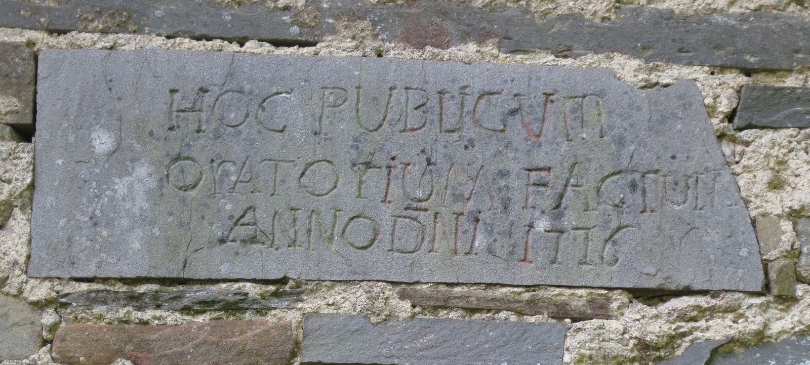
After a pleasant 15 minute walk, we reached the high mountain village of Formentara, and now the clock had been turned back again - by centuries. This abandoned villaggio alpestre was once used during the alpeggio - the seasonal agricultural/pastoral activities in high terrain. Formentara was established and utilized by people from the villages of Patigno and Noce, which are located about a 2 hour walk downhill and 400 meters lower. It was established at least 500 years ago, since the first mention is in 1508, and it's probably much older since use of the high mountains for grazing has been documented in Italy as early as 3,000 B.C. Although this village has been deserted for over one hundred years, it's relatively well preserved - considering. It has about thirty very evocative buildings located on both sides of a small mountain stream, as well as the Oratorio of San Bartolomeo from 1776.  The habitation is on a south facing slope, but below the summit and away from the north wind, and seemingly near the tree line - that is the altitude where weather conditions inhibit tree growth.
Travel Tip_____________________________________________________________________
Renting A Car in Italy. If you drive in urban areas at home, you can drive in Italy. Car rental prices are important, but don't rent based solely on low price and stick to well known companies. We have two articles to help you:  Link: Independent Car Rental Reviews for Italy and Link:Car Rental Tips for Italy - Pick It Up Right 
In them, we recommend the car hire broker Auto Europe where you can compare companies, reserve with a low price guarantee, purchase no deductible insurance, cancel easily, and have 24/7 customer service before and after the car hire. If you will rent a car and want to do us a favor, please use this link: Auto Europe.
__________________________________________________________________________________

Stone house of the Alpeggio of Formentara, Tuscany
House at Formentara used during the Alpeggio.
The walls are constructed 'pietra a secco' or 'muratura a secco' known similarly in English as 'dry laid' walls. Stones are laid on one another without mortar or clay to bind them together. This takes advantage of the flat stone available here (more below), but it is more vulnerable to foundation settlement, earthquakes, and it allows air passage - for better or worse. Many of the buildings share common walls, both for economy and structural integrity. The roofs are constructed of heavy beams topped with large flat stones overlapping one another - and that's all! This is known as 'in piagne' and this was the predominant roofing material in Lunigiana until railroads arrived*. Curiously, although we looked in quite a number of buildings, we didn't see any fireplaces or chimneys.

Stone roof called 'tetto in piagne'
Roof of overlapped rock, 'tetto in piagne'. Formentara village.
Imagine - there was enough value derived from these slopes in just 5 or 6 months to make a whole village worthwhile! Starting in late spring and lasting until mid-autumn, the village houses would be occupied with extended families. The biggest attraction of the higher slopes was pasture for sheep and goats. This was the base for the predominent activity - milking the herd and making cheese for use in winter and for trading. Many types of cereals and vegetables were also cultivated, but only those that could be raised within the shorter seasons of higher altitudes. Late in the season, chestnuts were hugely important. Gathered and roasted and shelled and ground to a flour, they provided a vital staple. While chestnuts were deficient in protein, resulting in stunted growth, they nonetheless provided sustenance.

The village was abandoned in the 2nd half of the nineteenth century as social and technological change altered the economy and thus the way of life in the mountains of Italy. The same trains that brought tegole (roof tiles) to replace the flat stone brought competition and opportunity, but manifestly not in equal measure.  The alpeggio -based on cattle - is still practiced further north in the Italian Alps, and hikers can visit seasonal refuges in a program called ERSAF Lombardia, and similar programs in Piedmont and the Trentino.  It's remarkable that Formentara has lasted as well as it has, for the building methods are inherently fragile, and surely it is unlikely to be restored. We're grateful that we could walk among these vestiges of a poor but knowledgeable people and be reminded that mankind forgets roughly as fast as it learns.

'This public oratorio was built Anno Domini 1776.'
Oratorio of San Bartolomeo,  Formentara (Lunigiana) Tuscany
After looking around the village - prudently we hope - we recommend following the marked trail uphill about a further 200 meters. As you approach a quarry (smooth rock slope) you can reach a world class picnic spot (see 1 minute video of the view) by following a grassy road to the left of the quarry, You'll reach the summit of the hill with views of 360 degrees. To the south you can see the highest peaks of the Alpi Apuane that are Carrara and Aulla's backdrop, as well as the convoluted folded hills that form the Zeri Valley. The mountain breezes are welcome, even if they steal your napkin.

Old Pietra Arenaria quarry (sandstone) Tuscany
Pietra Arenaria, grey sandstone, quarry in Zeri, Lunigiana.
The large old quarry which you can recognize by the steep, smooth, tilted rock wall.
This was a quarry for Pietra Arenaria, gray sandstone, used for centuries by local sculptors for ancient stele,  decorative doorways, and statues, including the mysterious local figures called facion. However, this rock outcrop would have been used for building stone since it would only yield relatively thin pieces, and it probably provided much of the rock you saw in Formentara. Here's a bit of geology: the sand of this future sandstone was deposited via water, and sometimes, when the water was low and brackish, mud was deposited as well. When the whole mass was squished into rock, the sand made a solid part and the mud made a crumbly part. If you look at the exposed cross section, you can see a 2 inch solid layer, a thin weak layer, a 6 inch solid layer, a thin weak layer, etc. Medieval stone workers would have taken advantage of this to break out sizes convenient for building, such as the thin but large roof pieces in the village. Our guess is that this quarry was also worked in modern times as well, since the waste stone has been moved aside. This quarry was worked a lot: the hill here has been moved back a good 50 meters.

Getting There
Exit the A15 Autostrada (Parma-La Spezia) at the Pontremoli exit, and turn right. Follow signs toward Pontremoli through several roundabouts and as you near Pontremoli, you'll see a sign to Zeri (via SP37). From there, it will take you about 30 minutes on a small, curvy, hilly road. Follow signs to Zeri, then to Zum Zeri (a ski area) and the Passo dei Due Santi and Formentara. We parked at the turn from the Zum Zeri road toward Formentara, but you can go by car about a kilometer further to a parking area near a Formentara sign where the road becomes impassable to a car.

More Info (in Italian)
Formentara article Turismo In Lunigiana
Blog Zeri  Storia Sulla Formentara
Ruralpini A site with history, types of cheese, types of animal - everything about the alpeggio.
*Piagne information: Pietra di Lunigiana, Impresa di Costruzioni.

Written by Martha

Getting to Portovenere in 2025 - A Transportation Guide.

How to Visit by Boat or Bus, Car or Hiking.

 Where to Stay in Portovenere & Links to More Information

Old Portovenere overview
Portovenere, Liguria.
Beautiful describes the town of Portovenere - so does stately and evocative and discreet. This jewel of Liguria is located on the western shore of the Gulf of La Spezia  - just 6 miles south (by air) from Riomaggiore, the southernmost village of the Cinque Terre. This article will help you get to Porto Venere* and for information on What to Eat and selecting a Portovenere hotel, scroll way down. For information on what to see, read Portovenere Travel Guide - The Top Ten Attractions and you also might like La Spezia Travel Guide - 10 Top Attractions.


Tall Portovenere buildings along waterfront
Waterfront buildings                                Portovenere, Liguria


Read Below 
 Portovenere    By Train
                          By Bus
                          By Ferry Boat & Boat Taxi
                          By Automobile & Parking

                          By Taxi 
    Hiking To Portovenere & Cinque Terre.
    Where to Stay.
    More Information.

    Sample Boat Schedule


Portovenere by Train.
There is no train to Portovenere. The closest train connections are La Spezia Centrale and four of the Cinque Terre towns (not Corniglia). At La Spezia the transfer is by bus, taxi, or ferry boat. From the Cinque Terre the transfer is by a ferry boat so weather, budget, & baggage are considerations.

Portovenere By Bus.
Bus from La Spezia to Portovenere
ATC bus line 11/P runs between La Spezia and Portovenere.
It's easy to take the bus from La Spezia to Portovenere. The excellent bus service to and from La Spezia is the 11/P bus line which runs along the shore road (SS530) to Portovenere, leaving about every 15 minutes all day long (but not from the train station).
From La Spezia, the trip takes about 35 minutes, and it's a codice 3 ticket. One main bus stop is Mercato Nord which is just north of La Spezia's open market on Corso Cavour (La Spezia Map: Train-Bus Transfer).  There are also other outbound bus stops, of course (one's near the soccer stadium) and they are found by means of the blue bus icons on the map referenced above. If you click the bus icon, a box appears with the stop's bus lines and times. You can read more about taking buses and free and pay parking in our article Getting Around: La Spezia. The Mercato Nord bus stop is a pleasant 10 minute walk from La Spezia Centrale train station.
Bus stop for La Spezia to Portovenere bus
La Spezia, Mercato Nord bus stop.
Ticket Sellers. Tickets are sold at most newstands and tobacconists, all post offices, some bars and stores. In La Spezia, the easiest for many will be the Centrale FS train station, where there's a self-service bus ticket machine. From the Mercato Nord bus stop, there's a newstand at the outdoor market nearby.  In Portovenere, tickets are sold at the Tourist Office (Pro Loco) near the entrance to the old town. There's also a self-service machine on the municipio (city hall) side of Via Garibaldi near the main bus stop - opposite the fruit store. If you buy from the bus driver, the price is doubled. 

From Sarzana, The bus from Sarzana to Portovenere requires a codice 7 ticket, and the bus leaves from Piazza Martiri, which is located near the center. Ask locally for directions. The bus leaves hourly and it takes about 70 minutes. On your return, make sure you get the Sarzana bus from Portovenere, since after reaching La Spezia each bus travels to a different destination. Consider also a train between Sarzana and La Spezia, and then the La Spezia-Portovenere bus.

For more detailed bus planning, see the ATC Website - where you can get a full or partial timetable and bus and parking info.  There's also an ATC Trip Planner  which will determine the route from your desired origin and destination and display it on a map. Remember that the schedules do not mention every bus stop, and the map icon info may not mention every bus stopping there. The schedules change around June 14 and September 15, though usually not significantly.

Travel Tip____Where to Stay______________________________     
A word to the wise: location is important in deciding on a Portovenere hotel, be sure to understand where your choice is located. Our six hotel recommendations below are listed from the old town outward. While some advertised 'Portovenere' hotels are a pleasant 20 minute stroll along the waterfront, others are in the hamlet of Le Grazie (della Baia, Le Grazie & Relais del Golfo, for example) which is a bus or car ride away! To see all Portovenere  hotels listed, use this link: Booking.Com.Portovenere 

Our notes on Portovenere hotel locations

Click on the Portovenere hotel link for more information and booking.
Grand Hotel Portovenere Recently renovated, the location overlooking the historic center cannot be better. Many rooms with sea views. Full service including free wifi. Parking on site is 20 Euro
Affittacamera La Darsena Darsena means wharf, and this B&B is right along the water in old Portovenere.
Hotel Genio is just outside the ancient wall surrounding the old part of Portovenere. Dogs welcome.
Affittacamera La Lanterna This B&B is just a few minutes outside the old area, along the waterfront. 
Hotel Belvedere is well located and maybe the most popular choice.
Hotel Paradiso is not far from the old town and closer to Portovenere's limited beaches.
Hotel Royal Sporting is a pleasant 20 minute stroll along the waterfront is. This is nearer to beach facilities, and anyway you'll need the walk after what you will eat.


________________________________________________________________________________
Portovenere By Boat.
Ferry boat to Portovenere & Cinque Terre
Ferry boat trip to Cinque Terre from Portovenere.
It's easy to reach to Portovenere by boat. The most realistic departure ports are La Spezia, Lerici, and four of the Cinque Terre towns (not Corniglia). While there's one RT daily from Levanto, locals recommend the train to Riomaggiore and then a boat from there.

Boat service begins around the end of March and ends after the 1st weekend of November. There are more trips on weekends and holidays, and in July and August. Look at our articles which have complete schedules, prices & info, Cinque Terre, Lerici, Portovenere Boat / Ferry Schedules. Verify schedules before your trip if your timing is tight. Keep in mind that the boats can be canceled for rough weather (which is uncommon in summer). 

In La Spezia, the boats leave from the western end of the Passeggiata Morin, which is the promenade along the waterfront, a 15-20 minute walk from the Centrale train station. There's lots of pay parking at nearby Porto Mirabello with pedestrian access over a cute suspension bridge to the ferry docks. Access to Porto Mirabello is from the roundabout where Via Italia meets Viale Amendola just west of the waterfront.

In Lerici, the dock is at the castle end of town, on one side of Piazza Garibaldi.

In Portovenere, the dock is where the auto road nears the waterfront at the edge of the old town.

Portovenere By Boat Taxi.
As befits a maritime community, you can arrange for affordable charter boat service for transport to or from Portovenere, as well as for tours, weddings, or facilitating unique hikes. This is an especially useful option if you have a group. The Consorzio Barcaioli is the local cooperative which has a price page (quoted per person with a 4 passenger minimum). Portovenere Taxi Boat is a small local charter and rental boat service.

Travel Tip__________________________________________________________________
Renting A Car in Italy. Car rental prices are important, but don't rent based solely on low price and stick to well known companies. We have some articles to help you:  
           Link: Independent Car Rental Price Comparisons for Italy                                    
           Link: Independent Car Rental Reviews for Italy 
           Link:Car Rental Tips for Italy - Pick It Up Right 
We advise getting your car from one of the companies with the fewest problems reported (Avis, Europcar, Hertz, Autovia, Budget) either direct or via a reputable car rental broker such as AutoEuropewhere you get added services without paying more -  24/7 help line before, during, and after the rental; easy changes and cancellation; as well as available less expensive zero excess (deductible) insurance.** We hope you'll make your reservation through these links -using the links do not raise your price.
AutoEurope(US)    Auto Europe(UK) 
_________________________________________________________________________________

Food specialties of Cinque Terre & Portovenere
Sgabei: Lunigiana DOC.
Portovenere By Automobile.
Driving to Portovenere. Driving your car rental to Portovenere through La Spezia is easy! The A15 autostrada exit becomes Via Carducci. Proceed straight about 2 km, and turn left, as directed by the blue Portovenere sign, onto Via Italia which is also SS1 (a/k/a the Roman Via Aurelia!). Proceed straight for about 2 km past La Spezia's lovely waterfront with its walkway, the Passeggiata Morin. The road will take a sharp right turn and then you're continuing straight as the road changes name to Viale Amendola. After about 1 km, turn left at a traffic light onto Viale Fieschi which is also SS530 following the blue sign to Portovenere and Cinque Terre. After another kilometer, at a giant intersection, you'll make a dull left turn toward Portovenere continuing on SS530. (The road to Cinque Terre will be forking to the right on SS370.) From there, the SS530 takes you to Portovenere without any serious decisions. You'll see some military installations; skirt the small seaside frazioni of Marola, Fezzano, and Le Grazie; be treated to some nice views of the Gulf; and after about 12 km and 20 minutes, you'll be there.


Portovenere parking
Pay Parking Machine
Parking in Portovenere Driving in Portovenere is even easier because there are no choices: there's just one one-way loop through town. There's also no decision regarding free parking - there isn't any: you must pay from 8am to 9pm from March 15 to October 15, or to 7 pm in low season.

 In early 2015, the high season hourly rates were listed to be Zone 1- 2.50E, Zone 2- 2.00E, Zone 3 & outlying Cavo- 1.50E. It would be more in the one underground garage in the town center. The outlying pay parking lots ('Cavo zone') can be reached by a shuttle (Giro) bus on weekends (April to Oct.) and daily in July and August. The round trip fare is 2€.

The parking receipt to display on your dashboard is issued by a machine and the ones we saw accepted coins and bills. Allow 2-3 hours for a simple tour of old Portovenere, 4-5 hours for a leisurely exploration with drinks or for a simple hike around the island of Palmaria. 

For parking an extended time, talk to your hotel, investigate the town's weekend or weekly rate, consider leaving the car in one of the free lots in La Spezia, or consider parking near one of the towns along the shore road (SS530) and taking the bus the rest of the way. See our article Getting Around: La Spezia which has information and links on parking in La Spezia.

Portovenere by Taxi.
For a taxi to Portovenere from La Spezia, there's Radio Taxi La Spezia phone 0187 523 523.  The fare in early 2013 was listed as 35€. There may be small extra charges for luggage and extra passengers. In Italy, taxi drivers do not expect a tip. For a taxi in Portovenere, the pro loco lists Daniele at 346.1573636.

Cinque Terre Hiking Trail to Portovenere and Palmaria Island
The Portovenere Promontory from near Campiglia on CAI trail 1, Sentiero del Crinale ( the Ridge Trail). Click to enlarge.
F to R: The peak Il Muzzerone, Byron's Grotto, the rock spur of San Pietro (note steeple), Palmaria Island, Tino Island.

Hiking to Portovenere.
Portovenere is the endpoint (or beginning) of one of Italy's most scenic trails - CAI 1, Portovenere to Levanto, also known as the Sentiero del Crinale (the ridge trail). It's a serious trail that runs through mountainous terrain, but it's not crazy steep or unusually dangerous. If you are starting a hike from Portovenere, the trail begins off the main piazza outside the old town, and climbs alongside the town wall.

Portovenere Cinque Terre trail marker
Trail 1 at Portovenere's town wall.
For hiking to Portovenere, there are several starting points besides Levanto. You can reach Trail 1 from all the Cinque Terre villages via connecting trails. Trail 1 can also be accessed by bus from La Spezia - either by the connecting Trail 4 from Biassa or as it passes through the town of Campiglia. For Biassa, bus 19 leaves almost hourly, and stops at Mercato North, among other stops (see the bus section). For Campiglia, it's bus 20 and it begins at Centrale FS train station and also stops at Mercato North. Note that beginning at Biassa or Campiglia allows a downhill round trip using the bus from Portovenere back to La Spezia!


The best Cinque Terre trail map
The best Cinque Terre map we could find. Click to enlarge, right click to save.

For a wanderful,  detailed look at the geography, drill down on this map of Europe: Reit- und Wanderkart. Also, before your hike look at the Parco Nationale delle Cinque Terre website for news and for a schematic trail map which will indicate closed trails. 

The estimated hiking time to Portovenere from Levanto is 12 hours, from Monterosso 11 hours, Vernazza 10 hours, Riomaggiore (the nearest train) is 4 hours, from Biassa 3 1/2 hours, and from Campiglia 2 hours. 

What to Eat
We have done the eating for you. Read about specialties of the area which includes Portovenere.
 Our story A Guide to the Local Food of La Spezia  covers pesto, focaccia, croxetti, mescuia, vermentino, and more. Are you hungry yet?

Travel Tip__________________________________________________________________
Liguria Hotel Guide+City Selector
Part 1 Liguria Hotel Guide & City Selector   Portovenere Hotels also Listed Below.
Lerici, Portovenere, La Spezia. Visit Cinque Terre & enjoy the Gulf of the Poets as well.
Part 2 Liguria Hotel Guide & City Selector
Levanto, Bonassola, Moneglia, Sestri Levante, Lavagna, Chiavari. Visit both Cinque Terre & Portofino.
Part 3 Liguria Hotel Guide & City Selector 
Rapallo, Santa Margherita, Portofino, Camogli, Recco. Towns on the perfect Portofino Peninsula.
________________________________________________________________________________
More Info
Palmaria Hiking Information about hiking Palmaria Island just across the channel from Portovenere.

Pro Loco Portovenere The local tourist association maintains a very informative site.

Integrated Route Planner This interactive transport timetable from the Ligurian region will give integrated routes within and between Ligurian provinces using both trains and buses. It only works about a week ahead, but it is a very helpful resource. Also adapted for Mobile Devices.

Trenitalia Link in English.

Some of our Liguria Travel Articles
Portovenere Travel Guide - The Top Ten Attractions Portovenere's attractions for reasonable folk
.
Castle to Castle Along the Gulf of the Poets All about Lerici across the Gulf - exploring, parking, hotels.
Getting Around La Spezia  Describes parking in La Spezia, as well as bus info and other goodies.
La Spezia Travel Guide: Top Ten Attractions as told by people who  have actually been there.
A Guide to the Local Food around La Spezia  Food of the area, as told by expert mangioni.
 
Getting to Portofino - Walking, Hiking, and More  Describes fabulous walking and hiking from Santa Margherita Ligure to Portofino.

The Most Beautiful Villages of Liguria Part 1 The Rock Villages A 7-part series covering 28 great little towns.

Which Guidebook to Buy?
First, buy your Cinque Terre guidebook before you arrive as you won't easily find them in Italy.  For a guidebook dedicated to Cinque Terre, the best by far is Pocket Cinque Terre Rick Steves   (Amazon US) (Amazon UK)  (Kindle UK). Most all of the Pocket Cinque Terre info is also included in Italy Rick Steves 2020  (Amazon US) (Amazon UK) which is Amazon’s best selling Italy guidebook.

For advice and reviews on guidebooks for Liguria, Florence, Rome, Venice & more, read our article:
All the Best Italy Guidebooks Reviewed


Buddy Can You Spare a Click? 

If we've helped, you can thank us by using these links to get quotes and/or reserve your car rental.
 AutoEurope(US)   Auto Europe(UK) or this link Booking.Com.Italy  for accommodation anywhere in Italy.

* Portovenere or Porto Venere, it's your choice. The Romans and the Comune use the two word version. Most sources, including most Italian government entities uses the one word version.

Send us a email if you hit a broken link or erroneous information.
Written by Martha