
 |
Portovenere from Palmaria Island.
|
 |
| Palmaria Sunset from Tellaro. Brian Dunt |
Read Below
A Hike Around Palmaria.
Aside: Mediterranean Ecosystem.
Aside: Portoro Marble.
Getting There.
Where to Stay.
More Information.
Aside: Mediterranean Ecosystem.
Aside: Portoro Marble.
Getting There.
Where to Stay.
More Information.
 |
| Trail signage, Palmaria |
Travel Tip_____________________________________________________________________
Renting A Car in Italy. If you drive in urban areas at home, you can drive in Italy. Car rental prices are important, but don't rent based solely on low price and stick to well known companies. We have two articles to help you: Link: Independent Car Rental Reviews for Italy
Link:Car Rental Tips for Italy - Pick It Up Right
We advise getting your car from one of the companies with the fewest problems reported (Avis, Europcar, Hertz, Autovia, Budget) either direct or via a reputable car rental broker such as AutoEurope (NOT autoeuropa, ending in 'a'). The advantages of using AutoEurope are the added services without paying more - low price guarantee; 24/7 help before, during, and after the rental; easy changes and cancellation; as well as available less expensive zero excess (deductible) insurance.** If you find our efforts helpful, you can thank us by making your reservation through these links -using the links do not raise your price.
AutoEurope(US) Auto Europe(UK) Avis(English) Avis(IT) Budget Rent A Car (English)
_________________________________________________________________________________
The first landmark is Fort Umberto I, The Fortress of the Sea. Built around the time of Italy's Unification, it's one of a long series of military fortifications in the area, each trying to defend against the newest weapons of the period. Despite the importance, there not much to see but
abandoned buildings and a locked gate. The advantage of the position
is obvious, since the passage to La Spezia harbor is close at hand. From
the gate, climb the path on the embankment to the right. It's not
marked but it rejoins to trail just as you'd expect. Our path then climbs
a bit and comes near to the asphalt road that is the easiest way across the island and leads to
Fort Cavour in the interior.
We walk in a southerly direction along
the eastern side of the island and eventually and gradually turn
westward. The path leads upward as the landscape changes to
Mediterranean macchia with views of the island of Tinto just
offshore.
A Mediterranean Ecosystem. Many areas of Palmaria comprise a distinct native ecosystem referred to as Mediterranean Macchia. It may look like an overgrown field, but it's an intricate environment of plant components which can survive in the rocky soil and withstand the dry, hot summer as well as the intense autumn rains. It is clear that Nature is experimenting because there are many different types of superficially similar grassy clusters and woody shrubs. Similar perhaps for us humans, but don't tell that to the birds, rabbits, and goats. Some plants typically present are arbutus, the ground cover myrtle, buckthorn, holm oak, mastic tree, and locust. Always present is our favorite - ginestra (broom). It is so sparse, so utilitarian in design with its spiky greenery and little blossoms – yet, almost in apology, it gives us its bright yellow flowers for much of the year. The air carries a memorable scent in the macchia, but it's subtle since the plants can't budget much evaporation. The most aromatic plants found will likely be laurel (bay leaf) and rosemary . For the botanically inclined, the Italian Wikipedia Macchia article has nice reference photos. For comprehensive information and photos of the region's plants and animals, see Escursioni Apuane Flora & Fauna.
 |
| Macchia on Palmaria near Portovenere, Tino Island in the background. |
 |
| Broom flower (Ginestra) |
As you climb, the macchia gives way to terraced fields showing different levels of cultivation, past and present, and there are now more trees. Soon the trail to the beach at Pozzale branches off left (for a longer hike, adding about 90 minutes, walk down to Pozzale and then Capo dell'Isola and then back up to rejoin our route). Our path climbs to the right toward the seaward western shore of Palmaria. When the views open up, the trail turns northward to parallel the coastline.
We are now heading up to the former Batteria del
Semaforo (lighthouse/cannon battery) now the Centro di Educazione
Ambientale (Center of Environmental Education or CEA). The trail is
generally across bare rock skirting the steep slopes that mark this
side of the island. Unseen below you, midway, is the Grotta dei Columba
(access by ladder) where archaeologists have found tools and other
evidence of human habitation from the Neolithic era ( that's like 5,000 years
ago!). As you gain height you'll see several large Portoro marble
quarries cut into distant cliff faces. These modern quarries were
active until the early 1980's and were located here to take advantage
of water transportation, attractive veining, and lack of fracturing.
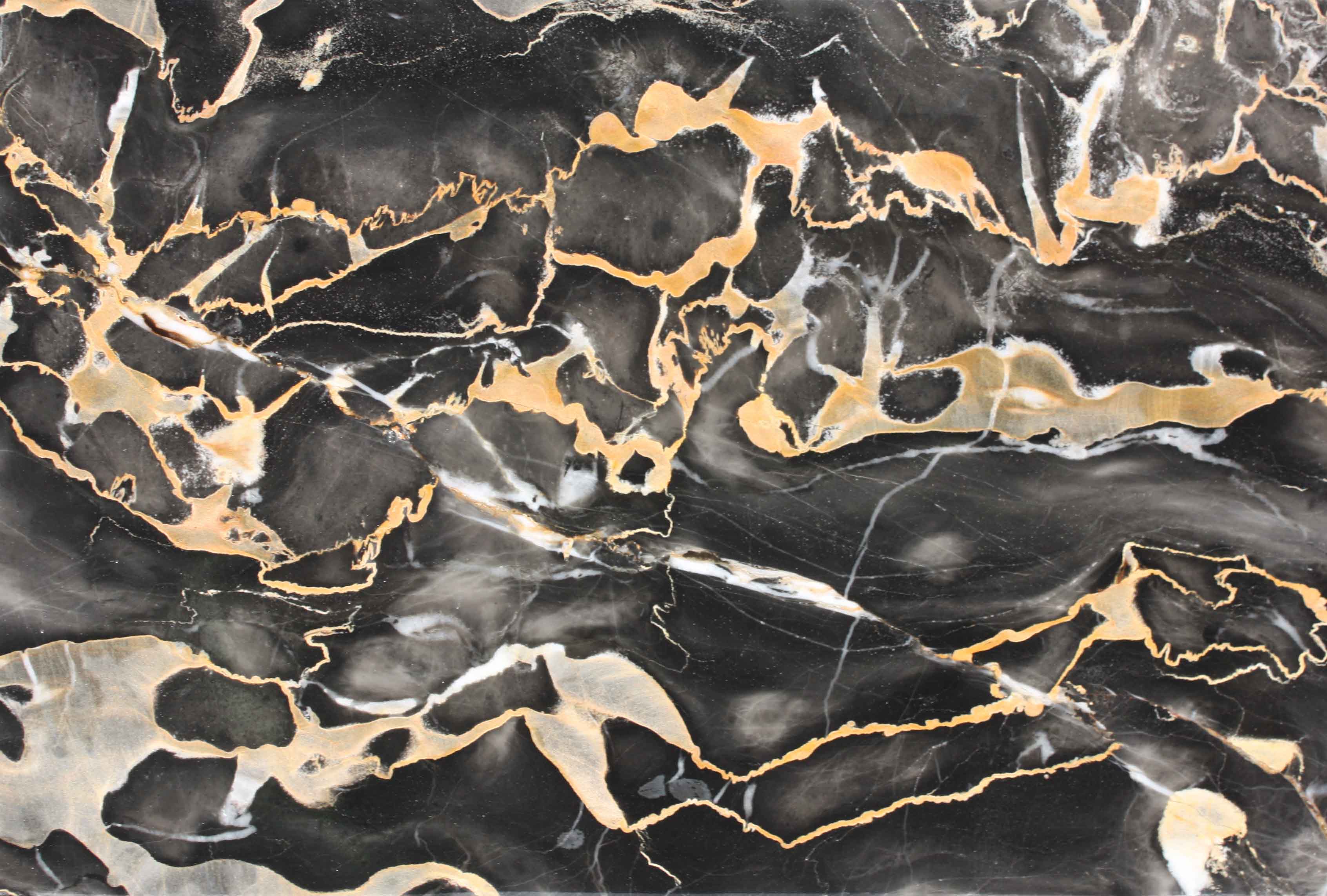 |
| A rich Portoro Marble example from Palmaria (Portovenere). |
In the 1600's the Roman quarries were reopened and an industry developed for the precious marble in Italy - often as church balustrades and columns (Sant'Andrea church in Sarzana). With Napoleonic control of the area, Portoro began to be used in fine buildings in northern Europe, such as Versailles, often as wall paneling and as a component of fine furniture (the word portoro is an Italian derivative of the French term, porte d'or). Palmaria was the most notable source over the centuries, with at least five quarries above and below ground, including Terrizzo and Pozzale. There were a few other quarries on the mainland including the mountainous area (Il Muzzerone) behind Portovenere, where there's still at least one working quarry today.
 |
| Palmaria's 500 foot cliffs are a favorite backdrop for sailboats. |
 |
| A Palmaria Goat. Click to enlarge. |
There's an attractive mix of fields and trees here and the trail comes closer to the cliffs, providing wonderful and scary views of sailing ships and sheer drops. These cliffs are 400-500 feet high – so it's little wonder the boats favor this setting - imagine the view they have. There are plenty of picnic places here with Maritime pines (a/k/a Umbrella pines) and Aleppo pines providing lots of deep shade. Some of the cliff flowers occur only here in these unique conditions.
 |
| St. Peter's, Portovenere. Montale: 'every near hour is ancient'. |
As the trail passes through a rocky excavated area, you start to get glimpses of Portovenere. Here you see the colorful slender buildings, and then there's the Church of St.Peter on its rocky point. The church's location is poetry and philosophy - as Montale said of it, "Here you are at the origins / and deciding is foolish." You will admire and you will walk and as soon as you take one photo, you'll walk 50 feet and there's an even better one. In the distance is the fantastic coastline leading to the Cinque Terre. Little wonder those villages were isolated!
 |
| The Cinque Terre / Portovenere Coast from Palmaria. |
First, get yourself to Portovenere, and for that we have a detailed article: Getting To Portovenere
The boat for Palmaria leaves Portovenere from Molo Doria, which is the first pier from the road (there's a little ticket booth nearby) and it costs 4.50 Euro RT. In high season which is June 15 to September 14, there are many trips so you just show up between 9am and 7pm.
In low season, September 15 to June 14, there are at least 9 trips daily. The schedule times posted on Nov. 2012) were 6:15 7:15 10:00 12:00 13:15 14:15 16:15 18:00 and 20:00 (the return is 10 minutes later).
In summer, there is ferry boat service from La Spezia to Terrizzo and Pozzale several times a day. See the schedules on our article Complete Gulf of La Spezia Ferry Boat Schedules
There are also affordable water taxi services available in Portovenere, see the Getting to Portovenere link above or inquire locally. They are useful if you have a group, would like to be picked up across the Gulf, or want a customized hike.
All of this is subject to change and to rough weather. In high season, there may be a boat that stops at Pozzale while on a tour of the islands, but we couldn't verify it - inquire locally if that's of interest.
Where to Stay.
Most people stay on the mainland, of course, but Trip Advisor's number 1 rated B&B for the area is on Palmaria.
La Casa del Pescatore The view is a VIEW! and the dog's name is Leon.
More Information.
Portovenere Travel Guide - The Top Ten Attractions Here's what you should see in Portovenere written by our favorite writers.
Pro Loco Portovenere is a pretty good website for a small town.
Parco Naturale Portovenere The park website has Palmaria history and trail descriptions (under 'tracks') in English.
Restaurants. There are two on the island. Il Pozzale in Pozzale on the far side of the island, and Locanda Lorena in Terrizzo which also has rooms and will send a motoboat to pick you up.
Travel Tip
Where to Stay in Cinque Terre?
_________________________________________________________________________________
Use the ferry to avoid the crowds while you enjoy the Gulf of the Poets towns. Read our descriptions and hotel recommendations:
Link: Guide to Portovenere Lerici La Spezia
_________________________________________________________________________________
Written by Martha